Search Anaspides Photos
Welcome Everybody

Hello - Welcome. The purpose of this site is to document my experiences photographing wildlife and nature throughout Australia and abroad.  I hope you find the content interesting and educational, and the images  cause you to reflect on how important it is preserve natural places and their inhabitants.

All wildife has been photographed in the wild and animals are NOT captive or living in enclosures.

For me photography of the natural world is more than just pretty settings and cuddly animal photos. It's a concern for the environment and the earth all living creatures must share.

Note that images appearing in journal posts are often not optimally processed due to time constraints.

You are welcome to comment on any post.


FlickR
500 Photographic Portfolio

Enter your email address:

Delivered by FeedBurner

Conservation Matters.....

Articles Archive (newest first)

Entries in Geology (4)

Thursday
Oct102013

Meet the Thrombolites - Ancient Life in Western Australia

I’ve spent the last few weeks in Western Australia exploring some of the region south of Perth.  My main aim was to find and photograph a number of orchid species found only in the south west of the state amongst the vast stands of Karri, Tingle, Tuart and Jarrah forests.  I also was keen to photograph the ancient mound-like algal mats called thrombolites that are known to inhabit areas along the coastal zone.

LEFT:  Thrombolite community, Western Australia (click image to view larger)

Thrombolites and Stromatolites - Biology and Life History

Many individuals have heard of stromatolites.  These ancient organisms (prokaryotes) are partly responsible for release to the atmosphere of increasing levels of oxygen.  This oxygen slowly replaced the methane-dominated atmosphere prevalent during the Achaean Period.  The microbes that form thrombolites and stromatolites produce oxygen as a byproduct of photosynthesis and precipitate calcium carbonate (biogenic limestone) which create the slow-forming dome-like structures.  Thrombolite communities only occur in warm, shallow, hypersaline and well lit waters.  

Thrombolites and stromatolites are a major constituent of the fossil record for about the first 3.5 billion years of life on earth, peaking in abundance approximately 1.25 billion years ago before declining in abundance and diversity by the start of the Cambrian Period.  Declining diversity is thought to be primarily because of the increase in grazing-type animals, such as gastropods, that evolved from the beginning of the Cambrian Period.

Growth rates are slow and are around 10 cm per 100 years; but it must be remembered that only they outer layer of the mound is alive.

Modern thrombolites and stromatolites are uncommon.  Specific environmental conditions are needed for their long-term development which includes a high temperature and hypersaline environment where the occurrence of grazing creatures is minimal.

What are Thrombolites and how do they differ from Stromatolites

Thrombolites are clotted, accretionary structures, formed in shallow water by the trapping, binding, and cementation of sedimentary grains by biofilms of microorganisms, especially cyanobacteria.  They exhibit a coarse, clotted fabric and laminae, if present, are indistinct.
The stromatolites are similar, but are well laminated with the outer surface displaying small, discrete knobs.  

Both thrombolites and stromatolites precipitate calcium carbonate; however the former precipitates aragonite, a carbonate mineral which is a crystalline form of calcium carbonate.  

LEFT:  Cross section showing internal structure of thrombolite and stromatolite.

Rarity

Thrombolites and stromatolites are not common and are “Living Fossils”.  They provide a key to the past as their form, structure and biology has not changed since their heyday in the Achaean Period.

Casuality of their own Success

Plate tectonics, and the competition for space, took their toll on the primitive thrombolites.  They were eventually a casualty of their own success. Newly evolving organisms were thriving in the improved oxygenated conditions, and found the thrombolites to be a very tasty meal.  They were slowly eaten off the face of the Earth.

Their legacy however, is the Banded Iron Formations (BIFS) that are backbone of the mining industry in Western Australia.  BIFS form by the oxidation of iron locked in sediments and could not have occured without an oxygenated atmosphere for which the thrombolites and stromatolites were largely responsible.  

The Toyota Landcruiser I drive would not be a possibility if these amazing organisms had not evolved…

Glossary

Hypersaline – A water body that has a very high concentration of sodium (salt)
BP – Before present
Plate Tectonics – The movement of the outer part of the earth’s crust due to eaerth’s interior heat
Lacustrine – Lake
Laminae – Layers added above each other similar to a layer cake
Gastropods - Phylum Mollusca comprising the snails and slugs
Achaean Period – Geologic Eon ~4000 – 2500 million years ago
Cambrian Period – Geologic Period ~550 – 490 million years ago
Quaternary Period – Geologic Period ~2.5 million years ago until present day

Sunday
Mar102013

Fossil Flora - Silcrete Plant Fossils; Evidence for Climate Change - Part Two

Hartley, 1967 stated “The past is a foreign country”

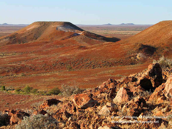
The validity of this statement becomes readily apparent looking across the vista of breakaways, dry sandy terrain, silcrete-covered ridges and dry gibber desert.  A stark contrast exists between the present day environment and the evidence presented by fossil flora of the very different conditions that prevailed here, when the fossils were deposited.  What had previously been a wet, lush, and green environment that supported a complex mosaic of tropical and temperate rainforest, is now devoid of all but the most resilient vegetation.

The content of this post, because of its scientific nature is rather specialised, however, I have attempted to succinctly explain the region’s local geology and provide evidence to how the fossils found in the area can be used to interpret climatic change.  To view an image larger, double click the image.

Geology

The region’s geology has been poorly studied, despite there being considerable interest because of the record of surface environments in the Eyre basin over the past 40 million years, and the famous silcrete floras and mammalian megafauna.  

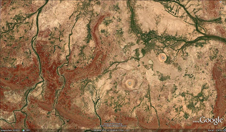
LEFT:  A satellite view of the region (courtesy Google Maps) clearly showing the drainage lines (green), gibber plains (light brown) and breakaways (dark brown).

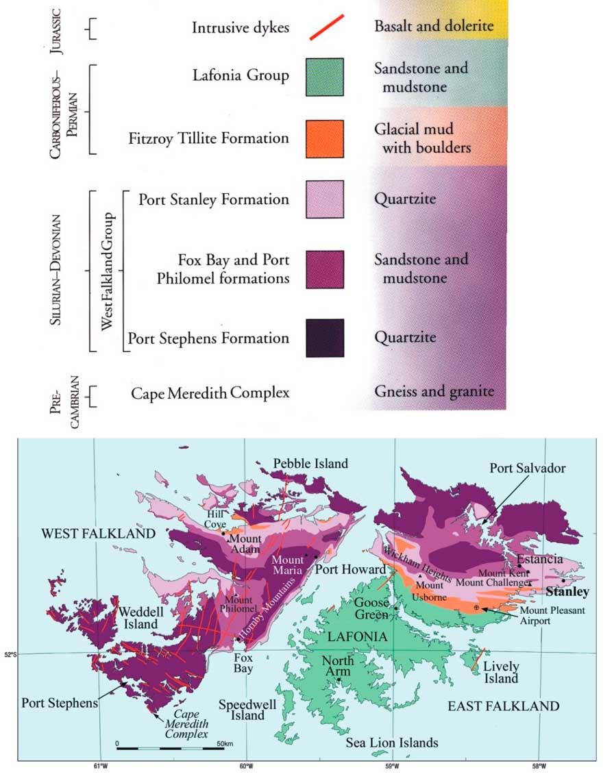
The geology is complex, in part because of the number of stratigraphic units involved and the interrelationship between lacustrine, fluvial, and aeolian sediments.  It’s this interrelationship and the variable development of duricrusts which has recently propelled the region’s interest, as these environments provide good scientific analogues for the surface of Mars.

The basement rock is comprised of marine deposited shale laid down during the Cretaceous Period when much of what is now inland Australia was covered in seawater.  The break-up of Gondwanaland and resultant rearrangement of tectonic plates gently deformed and duricrusted this shale, named the Bulldog Shale, to form the gibber plain uplands of the Stoney Desert.  The breakaways, prominent sentinels in today’s environment, are comprised of fluvial and lacustrine-derived sediments deposited during the Upper Triassic and Lower Tertiary, and were formed by erosion from several ephemeral streams including Coopers Creek.

Sedimentology and Palaeoenvironments   

I’ve attempted to provide a short introduction to the sedimentary units involved in the formation of the palaeochannel in which the fossils have been deposited. This interpretation is quite broad in content and further study and work needs to be done to accurately assign dates to the various stratigraphic units.  

Palaeoenvironment

The nature of the palaenvironment is well understood; a fluvial system with well-established oxbow lakes and shallow lakes surrounded by a mosaic of riparian tropical to temperate rainforest in a warm semi-tropical climate.

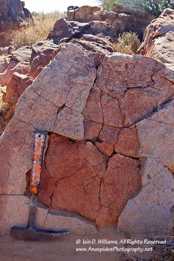
LEFT:  Indistinct to the untrained eye, this sandstone rock exhibits tell-tai sedimentary structures which indicate that the region was once covered in water.  The ripple marks can be used, amougst ither things, to interpreete water depth and current direction.

During the mid-Tertiary, the environment began to experience seasonality with fluctuating watertable levels; increased periods of semi-aridity began to alter the rainforest mosaic until species survived only around permanent water channels and lakes.  Eventually, as Australia and Antarctica separated and Australia moved north, aridity became more widespread and taxa became locally extinct.

The Watchie Sandstone Unit

The Watchie Sandstone is a lacustrine sequence comprising; in upwards succession, a local channel-sand facies and widespread lag deposits, a transgressive fine-grained lacustrine facies and regressive strandline deposits with a wavebase lag.  

Lag deposits indicate a low-gradient surface and strandlines incorporating pedogenic silcrete clast provide evidence of former soil horizons.    The palaeocurrent evidence is consistent with longshore processes and bar accretion onto a foreshore and larger bedforms indicate storm events.  Ridges have formed only along the eastern shoreline, indicating a strong westerly airstream and silicification and ferruginisation alternated during lacustrine regression.  

Insects (including ants and termites) lived in developing soil profiles and rhizonodules indicate that plants grew on these soils.   

The Willalinchina Sandstone Unit

This unit was deposited in a fluvial channel environment and is interpreted as a broad, shallow meandering to braided channel system which abuts a floodplain to a lacustrine palaeoenvironment.  Storm and associated flood events have also deposited bar, levee and floodplain deposits which interfinger with fluvial-derived sediments.   

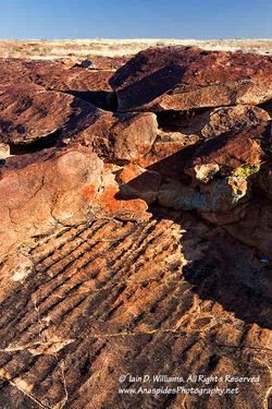
LEFT:  Partly eroded to show depth of the deposit, the structures clearly are indicative of sequential mud cracks that provide evidence of a drying environment.

Field observations support this interpretation:  A thin lens of basal conglomerate has been overlain by several meters of cross-bedded fine to medium-grained sandstone containing minor 
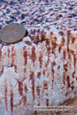
lenses of course-grained sandstone.  Silicification, caused by alternating watertable levels, has occurred in several places.    

Silcrete and Silicification

Silification provides evidence of a fluctuating watertable and, in general, a marked seasonality toward aridity, which inland Australia experienced during the mid Cenozoic. 

LEFT:  Reed mould or ant's nest silcrete - a possible interpretation is reed casts or methane gas escape structures from rotting vegetation.

The silcrete is defined by closely spaced vertical structures which have been referred to in past literature as “ants nest or reed mould silcrete”.  The vertical structures have been interpreted as reed casts, however, there is no evidence of organic matter found within the Willalinchina Sandstone Unit.  A possible alternative is soft sediment deformation caused by gas escaping from rotting vegetation.  This scenario would explain why the gas escape structures are not evident throughout the sandstone unit, but are preferentially preserved. 

Another interesting sedimentary structure preserved within the silcrete are circular mound-like features (below left) which have not been successfully interpreted. One theory suggests that the features are formed when liquid silcrete bubbled its way toward the surface, akin to how artesian water 
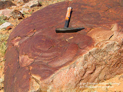
bubbled to the surface in nearby artesian spring moulds.

Silcrete is an indurated soil duricrust formed when silica is dissolved and resolidifies as a cement. It is a hard and resistant material, and though different in origin and nature, appears similar to quartzite.  Silcrete is relatively common in inland Australia, often forming the resistant cap rock on features like breakaways.

Stratigraphic Analysis and Age    

Sediments from the Palaeochannel have been placed in the Watchie and Willalinchina Sandstone units although most of the palaeochannel area is located within the later.  

Preliminary palaeobotanical work suggests that the Willalinchina Sandstone correlates with the youngest phase of the Eyre Formation in the Lake Eyre Basin and is Eocene in age.  The Watchie Sandstone has been interpreted as Miocene and correlates with the Billa Kalina Basin.  However, recent stratigraphic analysis may indicate that the Willalinchina Sandstone could be Miocene to Pliocene in age.  Further investigation needs to be made in this area before a definite date can be attributed to the palaeochannel.   

Floral Record - Interpreting Climatic Change   

The Australian Tertiary plant fossil record is very poor.  Studies indicate that tropical to temperate rainforests occupied  south eastern and south western Australia for much of the early-Tertiary with a contraction of these rainforest communities in the mid to late-Tertiary.   

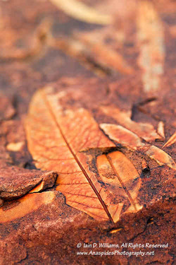
LEFT: One of many example of the fossil flora found in the area.  The state pf preservation is amazing and identification, in some cases, to species level is possible.

The discovery of the fossil flora confirm the palaeochannel is one of the richest, most extensive Tertiary plant fossil localities in Australia, if not globally.   

The botanical significance of silcrete fossils may be limited because silcrete formation is notoriously difficult to interpret and date with precision; however, the presence of extensive silcrete, caused by the fluctuating watertable levels does provide evidence consistent with marked climatic seasonality that occurred in inland Australia during the Cenozoic.  Therefore, floral assemblages could preserve evidence of the effect of climate change on the vegetation of inland Australia.

Initial Analysis    

Initial analysis of floral elements indicate a mosaic of plant communities dominated by sclerophyllous woodlands (Eucalypt spp.) and interspersed with riparian rainforests and deciduous marginal monsoon forests.  These plants grew along the watercourses where permanent water enabled them to survive seasonal dry periods.   

Interpretation of Fossil floras and Palaeoclimate     

Observational studies in tropical and temperate forests have demonstrated a direct relationship between leaf form (foliar physiognomy) and local climate.  For example; leaf length to leaf width and stomata number and size correlate to rainfall and ambient temperature.  

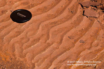
LEFT:  Ripple marks showing bifurcation of ripple crests indicate wave-formed ripples that have formed by wind blowing across shallow water.  The ripple marks are so clear, it's difficult to realize that they were formed approximately between 24 and 5 million years before present.

Mean canopy leaf size is also strongly correlated with mean annual temperature.   Palaeobotanical investigations of the botanical specimens found within the palaeochannel (Willalinchina Sandstone) provides valuable information on the mid-Tertiary distribution of Eucalyptus spp. and other plants.  

To date 245 leaf types, 47 fruit and seed types and 2 major wood types have been identified.   The sclerophyllous component (identified from linear to lanceolate leaf forms) dominated the flora and would have grown on the exposed drier plains in the more open forest areas of the floodplain.  

Many of the fossil leaves are indiscernible from extant Eucalyptus leaves and the minimal variation in leaf form suggests that Eucalyptus has existed in the area for ~15 million years.  The ecological niche of this species, based on this information, appears to be similar to that of extant Eucalyptus.    

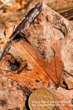
LEFT:  An excellent example of Banklsieaeformis praegrandi.  If you open this image (double click) you can see the preserved intricate patterns of the veins that have been preserved.  The red colour is caused by iron oxide that has percolated through the sediments.

The rainforest component of the flora grew in areas that provided a permanent water resource and are not present in the area today; their absence indicative of a changing climate and environment. As the climate became increasingly drier, these plants died out to eventually become confined to the present monsoonal and tropical rainforests of northern Australia and became locally extinct.   

Ancient Eucalyptus are not the only plant fossils that have been uncovered; numerous other plant species are likely to be extinct representatives of extant genera.  As with the Eucalyptus, similarity in leaf forms between fossil leaves and extant leaves have made identification problematic and it’s highly likely that many of these species were intermediate rainforest / sclerophyllous species sandwiched between the effects of climate change.     

One species that appears to have been positively identified from its deeply incised proteaceous leaf form is Banklsieaeformis praegrandi.  This fossil plant has been found in low numbers within the palaeochannel and has been linked to the extant species Banksia chamaephyton which is restricted to a small area of heathland in Western Australia (Greenwood, 1997).  

Access  

Access to this area is STRICTLY PROHIBITED without express permission from the land owner, property station manager, and approval from an educational facility such as University or museum.   Removal of fossils or collecting is NOT ALLOWED

LEFT:  Preferential erosion erodes the former land surface to leave the more harder and durable silcreted surface, in a formation called a breakaway; a term uniquely Australian.  The breakaways can reveal the surface of an environment that often is completely changed to that of today.  It's often difficult to grasp that approximately 70 million years ago these surfaces were the floor of a vast inland sea.

Next Journal Post

In the final post on this topic, we'll look at a number of photographs of the fossils and discuss the best method to photograph them in situ.

References   

Krieg, G. W., Rogers, P. A., Callen, R. A., Freeman, P. J., Alley N. F. and Forbes, B. G., 1991.  Explanatory Notes Curdimurka South Australia. 1:250,000 Geological Series Geological Survey of South Australia, Peacock Publications, pp 35 – 38.  Rowett, A., 1997.  Earthwatch '96.  MESA, Journal 5, pp 27-29. 

Monday
Jan212013

Fossil Flora - Searching For & Photographing Fossils To Document Climate Change - Part One

Dead things are usually not on my list to photograph, however, I jumped at the opportunity when tasked to photograph fossils at a location in far northern South Australia.  The fossils were deposited during the Tertiary Period (63 million years ago to 1.8 million years ago).  During this time the environment was very different to what it is today and much of Australia was blanketed in a mantle of green with humid temperatures; a far cry from the hot dry gibber deserts and sand dunes seen today.

LEFT:  Tracks are indistinct in gibber country.

The location of the fossil beds is remote, and a fully equipped four wheel drive vehicle is needed to negotiate the many small, unmarked tracks that eventually lead to the “jumping off” point to reach the fossils.  From this central location, where a base camp was erected, I explored via foot a number of low lying ridges and gullies that previously had been identified as being geologically suitable for fossil preservation.

This will be the first of two/three posts describing the 3 week camping trip in a relatively remote part of Australia.

Part of the Kidman Empire

Access to the fossils is via a number of badly maintained and eroded station tracks.  The tracks initially were constructed to allow pastoralists’ access to cattle which were run on the property.  At one stage, the property I was driving through was part of the vast Kidman Empire and was the largest cattle station (ranch) in the world, covering an area of 34,000 sq. km (6 million acres). Although the original property has since been sub-dived into smaller cattle stations, the area I was on is still 8,000 sq. km larger than its nearest rival in the Northern Territory of Australia, Alexandria Station. By contrast, the largest American cattle station “ranch” is 3,000 sq. km.  

The area I wanted to visit had been serviced by a station track, however, inactivity, sand migration and recent rains had caused the track to be indistinct; in several areas it had petered out completely.   Several creek beds and steep gullies needed to be traversed; the main concern being that sharp-sided rocks would puncture a tyre.  

Changing Environment

I had marked on a map the location I wanted to camp, this area being where I had established a base camp on an earlier visit several years ago.  I remembered the area was well protected from wind and several large Eucalyptus shaded the camp from the intense sun. 

LEFT:  This dry creek bed adjacent to the gibber plains was home for two weeks. 

However, floodwater and sand migration had altered the environment and the only way to get the vehicle to the campsite was to traverse a creek bed which was in-filled with deep, loose sand; on my previous visit the creek was loose rock and pebbles.  It's not uncommon for tracks and creek beds to be covered in moving sand in the desert areas of Australia; their mid-latitude produce constant seasonal winds that entrain sand and dirt and depositing it many kilometers from its origin.

I decided that bogging the vehicle in the sand wasn’t a good idea, for despite the four wheel drive having a winch, there wasn’t a suitable attachment point to connect the cable and winch to.  Therefore, a less than ideal camp site was chosen, with easier access, further along the creek line.

The camp site chosen was amongst a small grove of Eucalyptus growing alongside an ephemeral stream.  Bordering on both sides were vast gibber plains and low lying hills, which glistened during the heat of the day with the tell-tail shimmering of a heat mirage.

Exploring the Gibbers

Finding fossils in the desert is akin to finding a needle in a hay stack and a knowledge of geology helps identify areas prone to fossil preservation (I have post graduate studies in palaeontology).  Stony rises, coloured red-brown from oxidized iron are good places to look.  These rises, at the time of deposition millions of years ago, were flood plains, small lakes, or creek backwaters; ripple marks and other sedimentary structures preserved in the rock are evidence that support this.

Get Out & Walk….Warm Temperatures

I have always remembered a comment made by a legendary geologist during my university training “get out of the car and walk!”  “The rocks are waiting to tell you their stories” This advice seemed pertinent at this juncture as fossils can be small in size and usually can’t be seen from a moving vehicle.  Further, gibber desert environments are particularly sensitive to erosion and driving a heavy vehicle across gibber plains can compress the stones causing wheel ruts; ruts that will remain visible for many years to come.  This is a legacy I did not want to be responsible for.  Therefore, several days were spent carrying photographic and geological equipment, sometimes several kilometers each day, to explore the plains and low-lying gibber hills.

Walking was not uncomfortable in the early and late afternoon, but during the middle of the day when temperatures soured, we scrambled under what shade we could find, leaving the gibber surface to the ants which seemed to have immunity against the heat. 

One of Australia’s earliest explorers remarked that gibber environments are the most inhospitable places in Australia and in summer temperatures can reach well above 69 Degrees Celsius (in the sun).  During my visit, which was in early spring, the temperature on several days was 44 Degrees Celsius. 

Gibber Formation

The name gibber comes from the Aboriginal word for stone.  Gibber deserts are formed from the effect of constant seasonal winds that remove all sand and dust, but leave behind a highly eroded environment.  Rocks in this environment, often called gibber stones, appear highly polished, are wind-sculptured and exhibit a red-coloured desert varnish.

LEFT:  Gibber desert with ephemeral stream and vegetation.  You walked over gibber plains such as this for several kilometers each day to reach the fossilferous locations, often walking on a compass bearing with a GPS fix.

The red colouring comes from iron-rich or silica-rich material that has leeched over time, while the varnish is from constant polishing and scouring by sand entrained winds (similar to sand-blasting).  The gibber stones act as a "rock armour" protecting the delicate soil horizons beneath the stones.

Those gibber stones that are strongly wind-sculptured are called venifacts and are often used by earth scientists to determine paleowind direction; the side of the eroded and sculptured rock points toward the direction that the wind has blown for many thousands of years.

Desert Life - Gibbers

Although the ambient temperatures are extreme during the summer months, a number of animal species have made the gibber environment their home.  Spiders and ants can be found beneath stones; the spiders protect themselves from dedication by retreating into deep burrows emerging only to hunt at night and during overcast days when it’s cooler.  

LEFT:   The endemic Lozenge-marked Dragon (A. vadnappa) sunning itself on a venifact. 

On the gibber stones, the only reptile I found  was A. vadnappa basking in the midday sun.  The lizard remained motionless for over an hour; locomotion requires energy and in this harsh environment, if you don't need to move you don't!  A. vadnappa is endemic to this area and is not found elsewhere.

Along dry creek beds brown snakes were observed warming themselves on the warm sand.  Snakes and lizards are some of the more commonly found animals in inland Australia and vigilance is required to ensure you do not accidentally tread on a venomous snake.

Vegetation on the gibber plains is very sparse and acacias, desert peas and Eucalyptus spp. only grow in perfusion where the surface of the gibber plains has lost its protective "desert armour", such  as when eroded by the water from an ephemeral water course. 

Red Sand Dunes

Adjacent to the gibber plains is red sand dune country.   During the day you only see the tracks and sand excavations  of various animals in the shape of burrows, shelters and holes, however, at night the dune country comes alive with the glow of many eyes - testament to the large number of species that live in the soft sand or within the low lying scrub, which preferentially grows in the dune country.

Walking in the late afternoon and early morning I observed the Central Netted Dragon (Amphibolurus nuchalis), a large monitor lizard (varanus spp.), and several invertebrates such as the red grasshopper, red-sand spider and sand scorpion.  

Birds

Birds are obvious inhabitants of many environments and the Eucalyptus-lined creek beds provide an ideal habitat for many species.  Following extended rainfall and flood events, bird populations increase dramatically to take advantage of the additional food supply that seasonal water brings.  Lake Eyre, Australia’s largest salt lake had recently flooded and many bird species had extended their range to take into account the recent floodwater.

LEFT:  The ornate and beautifully patterned Central Netted Dragon (Amphibolurus nuchalis) was seen feeding on ants in the early morning.

Near the camp site a flock of corellas had made their home along with zebra finches, sulphur-crested cockatoos, ring-necked parrots, black shouldered kites and two peregrine falcons.  Large wedge-tailed eagles soared high on thermals in search of smaller mammals and unwary reptiles.

Recent Flooding (La Nina)

The climate in Australia waxes and wanes in response to the cycles of El Nino and La Nina; evidence for the latter, and its severity, being the flood debris piled some three-meters high against tree trunks, in what were now dry and dusty creek beds.  

Rainfall, although sparse in desert regions is not unheard of and torrential rain causing flooding can occur every decade or so.  During this time the gibbers are awash with water (sheet flow) and creeks are raging torrents of flood water entrained with sediment.  The water rejuvenates the area and Eucalyptus and Acacia seeds, long buried in the sand, begin to sprout and grow along with other native species such as grasses and small flowering perennials.  

Location, Access & Collecting

I purposely have not documented the actual location of this site.  Access is limited only for scientific research and  proof of research must be given to the landholder to gain permission.  Any extraction and collecting of fossils is forbidden.

Fossils - Photographing & Importance

Hopefully this post has set the scene. 

In two upcoming posts, we’ll describe the local geology, examine some of the fossils and discuss their interpretation and importance in relation to climate change in Australia.  We'll also look at various methods used to photograph the fossils.

Friday
Feb182011

Falkland Islands, South Atlantic - 1st Post

In late December and for most of January I was located in the Falkland Islands, a small archipelago of islands located off the southern most tip of Argentina in the South Atlantic ocean.  The Falkland Islands are renowned as a pristine environment of subtle beauty that is home to a wealth of fascinating wildlife.  My main reason for visiting these remote islands was to photograph the Black-browed Albatross and the Southern Elephant Seal – both species breed and haul out on several of the islands. 

LEFT:  Different coloured Landrovers parked in side street of Stanley attest to this vehicle's popularity in the Falklands.  To be honest, this is the first time I have seen a purple coloured landrover!

Geology, Geomorphology and Palaeogeography

The Falklands has an interesting geological history, with the oldest Granitic and Gneiss basement rocks forming during the Precambrian Period about 1000 million years ago.  Above these rocks lie the quartzites of the Port Stevens Formation.  These highly deformed metamorphic rocks, originally deposited about 420 million years ago during the Silurian Period, outcrop as the sea cliffs around Cape Meredith, the southernmost point of West Falkland.  

LEFT:  The eroded remains of a mountain range formed during the initial breakup of Gondwana. 

Palaeogeographical data indicates that the Falkland Islands were located adjacent to South Africa during the Lower Permian Period approximately 300 million years ago.  It was at this time that the major continental land masses that we know of today were joined together in a giant super continent named Gondwanaland.  During the Jurassic Period, around 200 million years ago, tectonic forces caused the large super continent of Gondwana to break up, and the continental plate on which the Falklands rested, slowly began to move westwards to reposition itself  adjacent to the geologically different Argentina.  To see a map showing the Falkland Islands geology click here.

At the beginning of the continental break up, major changes occurred at the margin of Gondwana when tectonic forces squeezed rock formations together causing intense folding, thrust faulting before forming a mountain range which is now seen as a thin spine migrating its way through the centre of the islands (see image above).  Later, the underlying rocks that carried the neophyte Falklands were intruded by several volcanic dykes, further aided in the separation process of an already fragmented continent. 

The Ice Age & Sea Level Rise

The present day scenery of the Falklands owes its origin in many cases to the effects of the last Ice Age.  Low lying hills supported small glaciers which carved their way downwards towards the sea.  In the wake of these glaciers are cirque lakes, rock crags, moraines and boulder streams -  often called rock runs.  During this time, areas not covered by ice were permafrost.  Eventually the climate warmed, and at the end of the ice age sea levels rose.  It’s because of this sea level rise that much of the island’s coastline in indented with bays and coves.  As the sea rose, it flooded low lying areas and river valleys producing meandering creeks and inlets that characterise many parts of the islands. 

ABOVE:  Boulder or rock streams called rock runs in the Falklands are caused by glacial and periglacial activity.  The rocks are moved by the continual thaw and freeze action of ice.

With the increase in ambient temperature came a change to the island’s vegetation.  Permafrost melted and was replaced with peat bogs some 3-4 meters in depth.  Because of the continual buffeting of gale force winds, the land’s surface is mostly treeless with the tallest tress being almost prone scrubs that closely resemble  Japanese ornamental bonsais.  Much of the land is covered in a variety of grasses of which tussock grass is the most obvious to the untrained eye.

Geopolitics and Colonisation

The islands were initially occupied by the  Spanish and French before being colonised by the British in the 1700’s.  The British used the islands as a base for whaling, sealing, and beef production and as a harbour for seafaring activities in South Georgia (more whaling & sealing).  A company was established called the Falklands Island Company (FIC) and it was through this company that many of the islands were initially inhabited.  Later, the company downsized due to economic constraints and many of the islands formally owned by the FIC were sold to individuals to do as they please.  Often the new owners took up pastoral activities and began to live a rural and frugal lifestyle.  Interestingly. Although the Falklands is closer to Argentina than Britain it’s not a colony, but rather a self governing territory; all administration is in-house with defence and  international policy being provided by the UK.  ABOVE:  The islanders are very proud of the heritage and often Union jacks and Falkland Island flags are flown or motifs painted on vehicles and houses.

The War

Politically the region sparked in 1982, when the Argentinean Government decided to invade the Falkland islands under the premise that the islands, because of their proximity, belonged to Argentina.  This was despite Argentina not having any past habitation of the islands.  The invasion began a 3 month war in which the invaders were repelled from the islands by the military forces of the United Kingdom.  Despite the passage of time, both adversaries hold little love for each other and minor non aggressive skirmishes occur on a regular basis.  The United Kingdom treat the situation seriously and have deployed Royal Airforce and Royal Navy units to the Falklands to provide continued military protection.  It’s not uncommon to be peacefully photographing wildlife on a secluded and remote headland to hear the load roar of two RAF Euro Fighters as they fly overhead on a routine patrol. 

ABOVE:  Not used and not dumped - an old Series 1 Landrover dating from the 1960's is left abandoned beside a shed in Stanley.  It's interesting to notethe chnage of colours that British Landrover used.  Dull greys, yellows and greens in the 60's that simulate the military heritage of this vehicle type, to bright colours in the late 90's such as purple, red, and racing car green; colours that appeal more to the "yuppy" generation.

Although I flew on a civilian airliner (LAN), ingress to the islands is via the RAF airbase located near the town of Stanley.  The first thing any visitor observes when leaving the aircraft is a number of heavily armed RAF military police with large dogs on leaches.  Signage indicates that military personnel are to be vigilant at all times and this is reinforced when travelling through the airbase after immigration control – armed soldiers are easily seen and it becomes obvious that the UK Military treat the Falklands is a forward base rather than a rest camp.

Islands in Time

Visiting the islands was very much like climbing out of a tardus time capsule; the present seems far away.   Everything looks and feels late 1950’s England.  Perhaps it’s the incredible number and diversity  of old Landrovers that ply the unsealed roads, the old sheds that litter nearly every backyard in Stanley, the “Doctor Who” red telephone boxes, or the fact that modern fashion has not seemed to have taken hold in this sleepy backwater of the UK.  One local proudly informed me that if the shop has my size, I buy it – colour and style have little to do with the purchase equation. 

If you were searching for words that describe life in the Falklands, it would be eclectic and functional.  Aesthetics has very little to do with how you do something; case in point being the green roof with pink second hand guttering – hey it works! 

Recycling, History and Gardens

What we classify as “junk” a local classifies as “something that may be of use – someday!  Everything is kept and often stored in a shed that takes pride and place along with a small local garden.  The small gardens remind me of “Victory Gardens” a term coined during the Second World War when Brits had to fend for themselves because of the Blitz.  It’s unfortunate that this concept of recycling  is out of vogue in many western countries whose occupants have a buy and throw away mentality.

Stanley is located along one side of an inlet in which on the opposite shore, outlined in large boulders are the names of many ships that have plied these waters.  One ship, the “Beagle” hints at a time when Charles Darwin visited the island to study it’s natural history.

Another aspect difficult not to notice, at least in Stanley, is the Falkland Islanders choice of paint colour.  Bright colours such as red, green, yellow and blue have been used paint the trim of some houses and sheds in an attempt to offset the otherwise bland colour of white wash.  On the roof of one house has been painted a large colourful union jack.  I learnt that the local council didn’t approve of the design  as it didn’t reflect the town’s style, however, the strongly nationalistic islander was not persuaded and the motif remains.

The Falklands is sparsely populated with roughly 2500 islanders, many of which inhabit the capital Stanley.  It’s because of this spare population and lack of large scale development that many of the surrounding islands are rich in wildlife. 

In my next post I will discuss some of the animals that call the Falkland’s home and include some wildlife photographs.