Four weeks SCUBA diving in Indonesia sounds like a good way to spend some time; however, swimming in an ocean devoid of anything larger than a sardine becomes worrisome in relation to the overall health of the reef ecosystem.
I was diving in the coral triangle in northern Indonesia based at Weda Island; a small island adjacent to Halmahera Island, the largest island in the northern archipelago, a region made famous by the nineteenth century naturalist Alfred Wallace and his discovery of the Standard-wing Bird of Paradise.
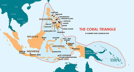 Coral Triangle
The Coral Triangle is a geographical term referring to a rough triangular area of tropical water between Indonesia, Papua New Guinea and the Philippines. The triangle encompasses two biological rich areas of marine biodiversity.
LEFT: Map of Coral Triangle courtesy (www.rareplanet.com). Click to enlarge.
Weda Island lies midway between the northern and southern regions; an area susceptible to strong currents, water transports large volumes of larvae which form the building blocks of a complex marine web and ecosystem.
Few Fish and Invertebrates. Siltation from Mining Operations
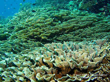
I became concerned after completion of several dives in habitats from near shore to coastal coral platforms and deep oceanic drop offs. There was something missing – FISH; in particular, anything larger than a “sardine”. There also was a general lack of invertebrates. It was as if the coral home was open but the inhabitants had left for the day...
Despite the lack of fish and critters, coral diversity on the outer reefs was excellent with massive and delicate corals growing from near surface to 30 plus meters. Unfortunately, two Chinese owned mining operations have caused siltation on inner shore reefs and inshore corals are degraded. So where were the reef dwellers?
Warm Water, Climate Change and Over Fishing
Certainly tidal currents and the moon phase can affect the presence of predators; however, I spent a month in this area and the results were the same for nearly every dive – very minimal fish life, poor invertebrate diversity, and no sharks whatsoever!
 In some areas the water was incredibly warm and the effects of temperature increase could readily be observed in some coral species in the form of bleaching.
The stress factor most commonly associated with bleaching is elevated sea temperature, but additional stresses such as high light intensity, low salinity and pollutants are known to exacerbate coral bleaching. If the causal stress is too great or for too long, corals can die.
Reef corals are very sensitive to sea temperatures outside their normal range. Elevated temperatures of 1 Degree Celcius above the long term monthly summer average are enough to cause coral bleaching in many dominant coral species.
When temperatures exceed threshold levels for long enough, the symbiotic relationship between the zooxanthellae and the corals breaks down and bleaching results. If stressful conditions prevail for long enough, the corals may bleach and die. However, if stressful conditions abate, then the bleached corals can recover their symbiotic algae and return to their normal, healthy colour. The severity of bleaching can vary substantially according to water depth, location and species of corals.
Is commercial over fishing, the local effects of nutrient run off from farming and industrial practices (mining), and perhaps the warming effect of global warming (current change and coral bleaching) beginning to be realized.
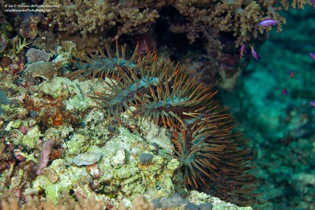 Crown-of-Thorns
Not seeing and watching fish, I did observe several Crown-of-Thorns starfish (Acanthaster planci) during my dives. Although this species can reach plague proportions decimating corals (they feed on the coral polyps), the sighting of a few animals does not in itself present a problem.
LEFT: Acanthaster planci is a large starfish that can consume live coral polyps at an alarming rate. Click to enlarge.
The crown-of-thorns starfish (Acanthaster planci) is a coral eating starfish or sea star native to coral reefs in the Indo-Pacific region. They are named after the dense spines radiating from their arms and they belong to the same group as all starfish, sea urchins, sea cucumbers and brittlestars.
Crown-of-thorns starfish are an important functional species on healthy coral reefs. They feed on the fastest growing corals such as staghorns and plate corals, allowing slow growing coral species to form colonies, therefore increasing coral diversity.
Is it Too Late ?
I have been diving since the late 1970’s and can remember vividly the days when sharks did worry you, there were too many fish to see anything past a few meters and the corals were strongly coloured without showing the effects of bleaching.
Is it too late? Over the last ten years I’ve observed a downfall in many areas that were previously teaming with fish and other marine life. Areas of Papua New Guinea, the Solomon Islands and parts of Australia that are “off the beaten track” and did have large number of fish now produce little…
On another trip to Indonesia, I was very conscious that at night, several large fishing boat flotillas passed our live-aboard dive boat - stripping the reef of the very fish we had seen the day before…
I believe the years are numbered in which newly-minted divers will experience what was seen by earlier generations. The over fishing, habitat destruction, lack of international pollution control, burdening populations in many coastal nations, and the need to feed people and profit from the oceans has taken its toll.
Whilst not every food species is directly affected, there is a flow-through effect that occurs when you remove one particular species from the chain, or reduce its numbers to near extinction (for example, sharks, tuna and predatory coral fish).
The next decade will be decisive to the overall state of environment concerning the marine ecosystem.
]]>;) "Our Homes Are GONE" It's as simple as that...
"Our Homes Are GONE" It's as simple as that...
;)
;)
;)
;)
;)
;)

;)
;)
;)
;)
;)
;)
;)
;)
;)
;)